
This route is not certified by the FEMECV. The alignment, technical data and waypoints below come from a user-submitted track published on Wikiloc (author: Kalendas, December 2025) and are provided solely for informational purposes and without commercial intent.
GuiaOnda has not walked this route, does not verify the current state of the alignment or signage, and assumes no responsibility for damages, accidents, becoming lost or losses arising from the use of this information. Before heading out, download the GPX track from Wikiloc, check current conditions and carry appropriate equipment. Information may be out of date.
The Maset – Marimón route combines access to the Marimón, one of the highest points in Onda's immediate surroundings (540 m), with several of the most representative elements of the low sierra: cork oak woodland, old farmhouses, springs and viewpoints with views over the Plana. At 8.4 km and 370 metres of elevation gain, it is a mid-difficulty route of comfortable duration, slightly longer than the SL-CV 107 Santa Bàrbara route and more accessible than the demanding SL-CV 142 Pic de Montí.
The start is in the town of Onda itself, and the route leaves the urban area quickly onto the first rural tracks. The climb to the Marimón viewpoint occupies the central section; the descent passes through the area of the Font del Retor (shared with the Pic de Montí corridor) and closes the loop at the Mirador de Onda, which gives a final view over the historic centre, the castle and the plain.
Route and waypoints
- 1Onda · Starting point: Departure from the town. The route climbs quickly towards the mountain.
- 2Pino Enano (2.1 km): A distinctive small-growth pine on the hillside. Visual landmark on the climb to the Marimón.
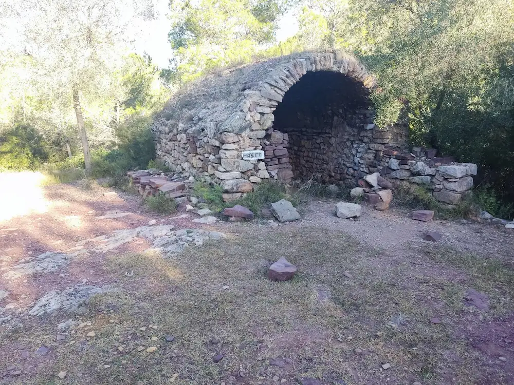
- 3Maset (3.1 km): A restored rural farmhouse among pine woods. The word "maset" in Valencian refers to a small mountain agricultural holding, and this is one of those that survive around the Marimón.
- 4Marimón viewpoint (4.4 km · 540 m): Highest point of the route. Broad panorama over the Plana Baixa, the Mediterranean and the Sierra de Espadán on the horizon. The visual centrepiece of the route.
- 5Font del Retor (6.1 km): Spring on the descent, shaded area among cork oaks. Rest stop shared with the SL-CV 142 Pic de Montí corridor.
- 6Mirador de Onda (8.1 km): Last point of interest before returning to town. Views over the city rooftops, the castle on the rock and the agricultural plain.
- 7Onda · Finish (8.4 km): The route closes the loop at the starting point.
What to see along the way
The Marimón is Onda's northern orographic reference point. The viewpoint at 540 metres offers a very different perspective from the Pic de Montí: closer to the town, with the castle in the foreground and the rooftops of the historic centre clearly visible from above. On clear days the Plana plain is laid out all the way to the Mediterranean.
The Font del Retor, on the descent section, is a historic water point on the corridor between the Montí and the Marimón. The cork oaks around the spring are substantial, with trunks marked by cork harvesting. The setting is cool and shaded, very welcome after the effort of the summit.
The Maset mid-route is a reminder of the mountain agricultural system that shaped this landscape for centuries: small farmhouses with kitchen garden, yard and access to communal paths, many abandoned during the twentieth century and some recovered as secondary residences.
Practical tips
The route is accessible for walkers with a reasonable level of fitness. The 370 metres of elevation gain are spread across a gradual climb without excessively steep sections. Bring enough water: the Font del Retor is the only water source on the route and may be dry in summer. Download the original GPX track from Wikiloc before you set off and carry it on a GPS-enabled device. On-the-ground signage is not guaranteed as this is not a certified route. Best seasons: autumn, winter and spring.